

Farnaz Khaghani: Can social media shorten commutes?
The following story was written in April 2018 by Addie Martin in ENGL 4824: Science Writing as part of a collaborative project that included the English department, the Center for Communicating Science, the Fralin Life Science Institute, and Technology-enhanced Learning and Online Strategies (TLOS).
If you go to Virginia Tech, you have more than likely heard someone lamenting the traffic in Northern Virginia.
“At its worst it can take me two hours to get from my job in downtown D.C. to my home in Alexandria,” says Leyna Holubar, a D.C. native and Virginia Tech alumnus. This is a distance of just about eight miles--and it is typical for short commutes to take this long.
Washington, D.C., consistently ranks among the top most congested cities in the United States, but Farnaz Khaghani and other researchers at Virginia Tech are working on ways to alleviate gridlock and related issues that ail infrastructure in high-traffic urban areas like the nation’s capital and other large cities.
“Our focus is on transportation systems and assessing their performance from different perspectives,” says Farnaz Khaghani, a second-year Ph.D. student in civil and environmental engineering at Virginia Tech. “For example, from a safety perspective, we look at accident rates in different areas and how they are related to the location of police stations. Another perspective would be pollution and how much different sections of road contribute to the general emissions of the urban area. And the other one is the ability of transportation systems to absorb the disruption of something like the rush hour traffic or an accident.”
To identify which areas should be highly prioritized for improvement, data must be collected. Conventional data collection methods to measure the performance of infrastructure are costly, requiring the construction of monitoring stations, which do not always reflect an accurate enough picture of the situation.
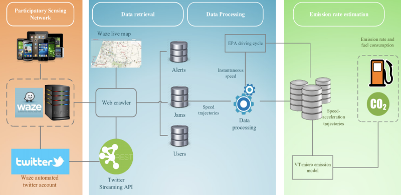
Khaghani, however, started looking for new methods to evaluate the performance of urban infrastructures and found participatory sensing a promising, new, and cost-effective approach. Participatory sensing is the concept of communities voluntarily contributing information to build a body of knowledge or set of information using social media data collected from smartphones.
“The main benefit of using this type of data source and this type of method is that it provides high resolution in a spatial-temporal sense of the situation, and there is little additional cost because you already have this application on your mobile phone—you don't need to implement any new infrastructure,” said Khaghani.
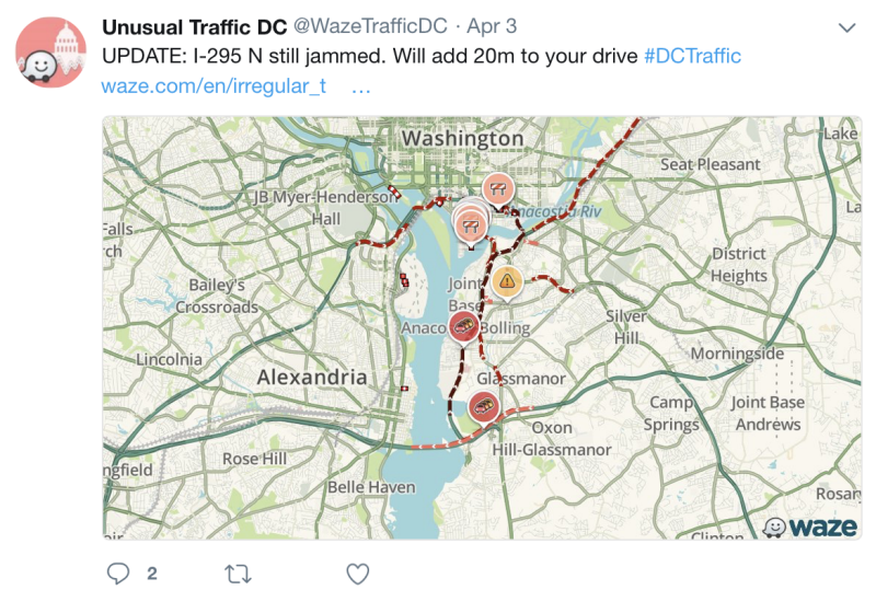
Employing web-crawling software that she programmed, Khaghani collects information from the GPS navigation application Waze. Waze describes itself as a “community based traffic and navigation app” and invites drivers to participate in sharing “real-time traffic and road info.”
Gathering this data is not without its challenges. “Doing the web crawling for these large areas is a bit cumbersome for the server. [Waze] may block you because they can think that you're somehow hacking them,” Khaghani explained.
To get around this, she uses traffic reports from Twitter as a gateway to narrow in on the specific locations of problem areas, extracting only the data she needs.
This innovative approach is impressive not only because she is among the first to use Waze for infrastructure performance evaluation, but also because this is her first major interdisciplinary project that reaches outside of her home department of environmental and civil engineering.
“I am not a computer science student. My background is all in civil engineering. I mean, I had some programming background, but it was a bit challenging to figure this out all by myself—how to get access, crawl the Web site, mine data,” Khaghani reflected.
Khaghani received her bachelor’s degree in civil and environmental engineering and a master’s in construction engineering and management from Sharif University of Technology in Tehran, Iran. She began her Ph.D. studies at Virginia Tech in the fall of 2016.
This solid background in engineering helped her reach the general definition of her research, but integrating the computer science aspect has made it wholly new.
“I am mainly interested in leveraging the emerging big data sources towards improving the performance of the infrastructure to move toward a sustainable and resilient community,” said Khaghani. For her, this means safer, cleaner, and more efficient transportation.
Though more research and development is needed, Khaghani says that her ultimate goal is to use this data to build a real-time platform, “so it can be a kind of recommendation system for drivers and give them some recommendation for the route they're choosing to mitigate pollution or just lead them to a safer road for their travels.”
Images courtesy of Farnaz Khaghani and Farrokh Jazizadeh